


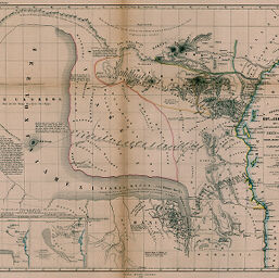
Skizze Einer Karte eines Theils von Ost u.Central Afrika...des See's von Uniamesi...von Jakob Erhardt u. Johann Rebmann
Permalink
https://digital.library.illinois.edu/items/366c7ab0-e946-0133-1d3d-0050569601ca-7
This item is in the public domain.
Descriptive Information
| Title | Skizze Einer Karte eines Theils von Ost u.Central Afrika...des See's von Uniamesi...von Jakob Erhardt u. Johann Rebmann |
| Creator | Rebmann, Johann |
| Date | 1856 |
| Dimensions | 33.7 x 43 cm |
| Place of Publication | Germany |
| Cartographic Scale | 1:5,000,000 |
| Notes | Includes 2 inset maps contrasting Petermann's and Erhardt's representations of "See's von Uniamesi" [i.e., Lake Tanganyika]. |
| Coverage-Spatial | Great Lakes (Africa) |
| Subject | |
| Genre | Maps |
| Language | German |
| Color | Bitonal |
| Technique | Lithography |
| Source | Petermanns geographische Mitteilungen, V. 2, plate 1. |
| Physical Location | stx |
| Map No. in Bassett and Scheven Bibliography | 1097 |
| Call Number | Q_910_5PE |
| Map ID | afm0001097 |
| Rights | No Copyright - United States |
| Rights Description | This item is in the public domain. |
| Collection Title | Maps of Africa to 1900 |
| Repository | Rare Book & Manuscript Library |
| Type | Cartographic material |
| Collection | Maps of Africa to 1900 |
Download Options
|
Skizze Einer Karte eines Theils von Ost u.Central Afrika...des See's von Uniamesi...von Jakob Erhardt u. Johann Rebmann |
Contact us
for questions and to provide feedback.