
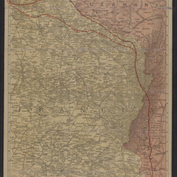
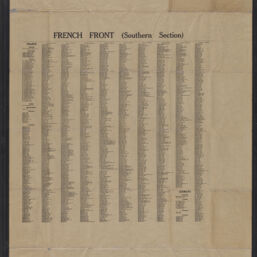
Rand McNally war map of the French front : southern section : strategic map of the battle ground in northern France from St. Mihiel to the Swiss border
Permalink
https://digital.library.illinois.edu/items/36a3bc80-9def-013c-4aba-02d0d7bfd6e4-8
No Copyright - United States
Descriptive Information
| Title | Rand McNally war map of the French front : southern section : strategic map of the battle ground in northern France from St. Mihiel to the Swiss border |
| Alternative Title |
|
| Creator | Rand McNally and Company |
| Scale | Scale 1:253,440. 1 in. equals 4 miles |
| Place of Publication |
|
| Publisher | Rand McNally and Company |
| Date of Publication | 1918 |
| Extent | 1 map : color |
| Dimensions | 80 x 54 cm, folded to 16 x 11 cm |
| Notes |
|
| Coverage-Spatial | France |
| Language | English |
| Subject | World War, 1914-1918 |
| Genre | Maps |
| Rights | No Copyright - United States |
| Rights Description | No Copyright - United States |
| Type | Cartographic material |
| Repository | Map Library |
| Local Bib ID | 99955030077005899 |
| Collection Title | World War I Maps |
| Collection | World War I Maps |
Download Options
|
99955030077005899-001 | |
|
99955030077005899-002 |
Contact us
for questions and to provide feedback.