


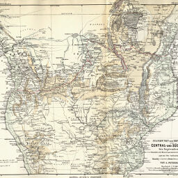
Standpunkt der Erforschung von Central-und Süd-Afrika bis Septembre 1876
Permalink
https://digital.library.illinois.edu/items/36a4d5c0-e946-0133-1d3d-0050569601ca-8
This item is in the public domain.
Descriptive Information
| Title | Standpunkt der Erforschung von Central-und Süd-Afrika bis Septembre 1876 |
| Creator | Hellfarth, D.C. |
| Date | 1876 |
| Dimensions | 24.2 x 31 cm |
| Cartographic Scale | 1:12,500,000 |
| Notes | Relief shown by hachures and spot heights. |
| Coverage-Spatial | Africa, Eastern |
| Subject | |
| Genre | Maps |
| Language | German |
| Color | Hand colored |
| Technique | Lithography |
| Source | Petermanns geographische Mitteilungen, V. 22, plate 20. |
| Physical Location | stx |
| Map No. in Bassett and Scheven Bibliography | 283 |
| Call Number | Q_910_5PE |
| Map ID | afm0000283 |
| Rights | No Copyright - United States |
| Rights Description | This item is in the public domain. |
| Collection Title | Maps of Africa to 1900 |
| Repository | Rare Book & Manuscript Library |
| Type | Cartographic material |
| Collection | Maps of Africa to 1900 |
Download Options
|
Standpunkt der Erforschung von Central-und Süd-Afrika bis Septembre 1876 |
Contact us
for questions and to provide feedback.