
Political Map of South America and Africa Adapted to Woodbridge's Geography
Permalink
https://digital.library.illinois.edu/items/36d64170-e946-0133-1d3d-0050569601ca-7
This item is in the public domain.
Descriptive Information
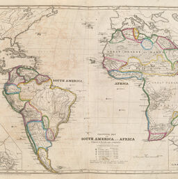
| Title | Political Map of South America and Africa Adapted to Woodbridge's Geography |
| Creator | Woodbridge, William C. (William Channing), 1794-1845 |
| Date | 1843 |
| Dimensions | 27 x 42.5 cm |
| Place of Publication | United States |
| Cartographic Scale | 1:43,500,000 |
| Coverage-Spatial | Africa |
| Genre | Maps |
| Language | English |
| Source | Modern Atlas, plates 13-14. |
| Physical Location | rbx |
| Map No. in Bassett and Scheven Bibliography | 201 |
| Call Number | XQ_912W851M1843 |
| Map ID | afm0000201 |
| Rights | No Copyright - United States |
| Rights Description | This item is in the public domain. |
| Collection Title | Maps of Africa to 1900 |
| Repository | Rare Book & Manuscript Library |
| Type | Cartographic material |
| Collection | Maps of Africa to 1900 |
Download Options
|
Political Map of South America and Africa Adapted to Woodbridge's Geography |
Contact us
for questions and to provide feedback.