
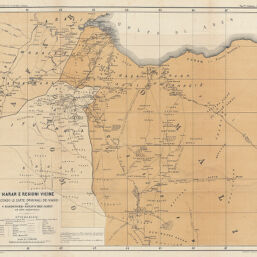
Harar e regoni vicine secondo le carte originali dei viaggi di V. Hardegger-Paulitschke-James ed altri esploratori
Permalink
https://digital.library.illinois.edu/items/37f33760-e946-0133-1d3d-0050569601ca-f
This item is in the public domain.
Descriptive Information
| Title | Harar e regoni vicine secondo le carte originali dei viaggi di V. Hardegger-Paulitschke-James ed altri esploratori |
| Creator | Società Geografica Italiana |
| Date | 1886 |
| Dimensions | 41 x 46.5 cm |
| Place of Publication | Italy |
| Cartographic Scale | 1:2,000,000 |
| Coverage-Spatial | Africa, Eastern |
| Genre | Maps |
| Language | Italian |
| Color | Printed color |
| Technique | Lithography |
| Source | Bollettino della Societa geografica italiana, ser. 2, V. 11, between pp. 92-93. |
| Physical Location | stx |
| Map No. in Bassett and Scheven Bibliography | 1297 |
| Call Number | 910_6SORSER_2 |
| Map ID | afm0001297 |
| Rights | No Copyright - United States |
| Rights Description | This item is in the public domain. |
| Collection Title | Maps of Africa to 1900 |
| Repository | Rare Book & Manuscript Library |
| Type | Cartographic material |
| Collection | Maps of Africa to 1900 |
Download Options
|
Harar e regoni vicine secondo le carte originali dei viaggi di V. Hardegger-Paulitschke-James ed altri esploratori |
Contact us
for questions and to provide feedback.