
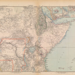
Afrika in 6 Blättern (Sheet 4)
Permalink
https://digital.library.illinois.edu/items/38651a80-e946-0133-1d3d-0050569601ca-a
This item is in the public domain.
Descriptive Information
| Title | Afrika in 6 Blättern (Sheet 4) |
| Creator | Lüddecke, Richard |
| Date | 1889 |
| Dimensions | 35 x 42 c.m. |
| Place of Publication | Gotha (Germany) |
| Cartographic Scale | 1:10,000,000 |
| Notes | Insets of Perim and Bab el Mandeb at different scales. |
| Coverage-Spatial | Africa, Eastern |
| Genre | Maps |
| Language | German |
| Source | Stieler's Hand_Atlas. Gotha: Justus Perthes, No 69. |
| Physical Location | Professor Thomas Bassett Personal Collection |
| Map ID | afm0003092 |
| Rights | No Copyright - United States |
| Rights Description | This item is in the public domain. |
| Collection Title | Maps of Africa to 1900 |
| Repository | Rare Book & Manuscript Library |
| Type | Cartographic material |
| Collection | Maps of Africa to 1900 |
Download Options
|
Afrika in 6 Blättern (Sheet 4) |
Contact us
for questions and to provide feedback.