
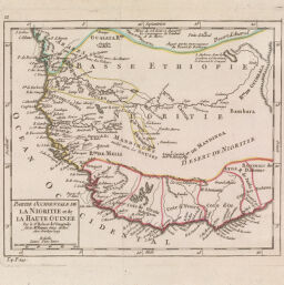
Partie Occidentale de la Nigritie et de la Haute Guinée...
Permalink
https://digital.library.illinois.edu/items/3938a8d0-e946-0133-1d3d-0050569601ca-a
This item is in the public domain.
Descriptive Information
| Title | Partie Occidentale de la Nigritie et de la Haute Guinée... |
| Creator | Robert de Vaugondy, Didier, 1723-1786 |
| Date | 1749 |
| Dimensions | 16.5 x 19.5 cm |
| Place of Publication | Paris (France) |
| Cartographic Scale | 1:13,000,000 |
| Coverage-Spatial | Africa, West |
| Genre | Maps |
| Language | French |
| Source | Le Petit Atlas. Paris, 1749. |
| Physical Location | Professor Thomas Bassett Personal Collection |
| Map ID | afm0003024 |
| Rights | No Copyright - United States |
| Rights Description | This item is in the public domain. |
| Collection Title | Maps of Africa to 1900 |
| Repository | Rare Book & Manuscript Library |
| Type | Cartographic material |
| Collection | Maps of Africa to 1900 |
Download Options
|
Partie Occidentale de la Nigritie et de la Haute Guinée... |
Contact us
for questions and to provide feedback.