
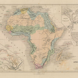
Afrique
Permalink
https://digital.library.illinois.edu/items/39af9530-e946-0133-1d3d-0050569601ca-7
This item is in the public domain.
Descriptive Information
| Title | Afrique |
| Creator | Périgot, Charles |
| Date | 1870 |
| Dimensions | 30 x 42 cm |
| Place of Publication | Paris (France) |
| Cartographic Scale | 1:29,500,000 |
| Notes | Inset maps of Sénegambie, Delta et Isthme de Suez, and Détroit de Bab-el-Mandeb. |
| Coverage-Spatial | Africa |
| Genre | Maps |
| Language | French |
| Source | Atlas General, Ch.Delagrave and Cie, Editeurs. Paris, 1870 |
| Physical Location | Professor Thomas Bassett Personal Collection |
| Map ID | afm0003139 |
| Rights | No Copyright - United States |
| Rights Description | This item is in the public domain. |
| Collection Title | Maps of Africa to 1900 |
| Repository | Rare Book & Manuscript Library |
| Type | Cartographic material |
| Collection | Maps of Africa to 1900 |
Download Options
|
Afrique |
Contact us
for questions and to provide feedback.