


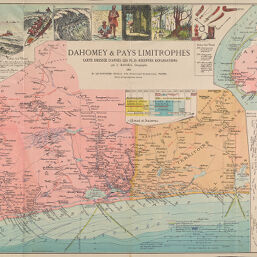
Carte du Dahomey
Permalink
https://digital.library.illinois.edu/items/3a2d6270-e946-0133-1d3d-0050569601ca-6
This item is in the public domain.
Descriptive Information
| Title | Carte du Dahomey |
| Creator | Hansen, Jules, 1849-1931 |
| Date | 1892 |
| Dimensions | 38.5 x 57 cm |
| Place of Publication | Paris (France) |
| Cartographic Scale | 1:500,000 |
| Notes |
|
| Coverage-Spatial | Africa, West |
| Genre | Maps |
| Language | French |
| Source | H. Le Soudier, Ed. 174, Bvd. St. Germain, Paris. |
| Physical Location | Professor Thomas Bassett Personal Collection |
| Map ID | afm0003099 |
| Rights | No Copyright - United States |
| Rights Description | This item is in the public domain. |
| Collection Title | Maps of Africa to 1900 |
| Repository | Rare Book & Manuscript Library |
| Type | Cartographic material |
| Collection | Maps of Africa to 1900 |
Download Options
|
Carte du Dahomey |
Contact us
for questions and to provide feedback.