
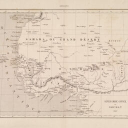
Sénégambie, Guinée et Soudan, 1847
Permalink
https://digital.library.illinois.edu/items/3a8b52b0-e946-0133-1d3d-0050569601ca-1
This item is in the public domain.
Descriptive Information
| Title | Sénégambie, Guinée et Soudan, 1847 |
| Date | 1847 |
| Dimensions | 18 x 22.5 cm |
| Place of Publication | Paris (France) |
| Cartographic Scale | 1:20,000,000 |
| Coverage-Spatial | Africa, West |
| Genre | Maps |
| Language | French |
| Source | Complement de L'Encyclopedie Moderne ou Dictionnaire Abrege des Sciences, des Lettres des Arts de L'industrie, de L'agriculture et du commerce Atlas. Paris, Librairie de Firmin-Didot, 1875. |
| Physical Location | Professor Thomas Bassett Personal Collection |
| Map ID | afm0003067 |
| Rights | No Copyright - United States |
| Rights Description | This item is in the public domain. |
| Collection Title | Maps of Africa to 1900 |
| Repository | Rare Book & Manuscript Library |
| Type | Cartographic material |
| Collection | Maps of Africa to 1900 |
Download Options
|
Sénégambie, Guinée et Soudan, 1847 |
Contact us
for questions and to provide feedback.