
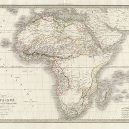
Carte d'Afrique, Dressee par M. Lapie, Lieutenant Colonel et M. Lapie fils, Capitaine d'Etat Major...
Permalink
https://digital.library.illinois.edu/items/3ac40450-e946-0133-1d3d-0050569601ca-3
This item is in the public domain.
Descriptive Information
| Title | Carte d'Afrique, Dressee par M. Lapie, Lieutenant Colonel et M. Lapie fils, Capitaine d'Etat Major... |
| Creator | Lapie, M. (Pierre), 1779-1850 |
| Date | 1831 |
| Dimensions | 39.5 x 54 cm |
| Place of Publication | Paris (France) |
| Cartographic Scale | 1:22,500,000 |
| Coverage-Spatial | Africa |
| Genre | Maps |
| Language | French |
| Source | 50 rue Mazarine, Chez Eymery Fruger Cie, Atlas Universel, 1937 edition. Paris, 1831. |
| Physical Location | Professor Thomas Bassett Personal Collection |
| Bibliography |
|
| Map ID | afm0003054 |
| Rights | No Copyright - United States |
| Rights Description | This item is in the public domain. |
| Collection Title | Maps of Africa to 1900 |
| Repository | Rare Book & Manuscript Library |
| Type | Cartographic material |
| Collection | Maps of Africa to 1900 |
Download Options
|
Carte d'Afrique, Dressee par M. Lapie, Lieutenant Colonel et M. Lapie fils, Capitaine d'Etat Major... |
Contact us
for questions and to provide feedback.