
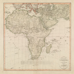
Atlas des ganzen Erdkreises in der Central-Projection entworfen von C.G. Reichard. Erste Tafel, 1803
Permalink
https://digital.library.illinois.edu/items/3ad081e0-e946-0133-1d3d-0050569601ca-f
This item is in the public domain.
Descriptive Information
| Title | Atlas des ganzen Erdkreises in der Central-Projection entworfen von C.G. Reichard. Erste Tafel, 1803 |
| Creator | Reichard, C. G. (Christian Gottlieb), 1758-1837 |
| Date | 1803 |
| Dimensions | 43 x 42.5 cm |
| Cartographic Scale | 1:22,500,000 |
| Coverage-Spatial | Africa |
| Genre | Maps |
| Language | German |
| Source | Atlas des Ganzen Erdkreises |
| Physical Location | Professor Thomas Bassett Personal Collection |
| Bibliography |
|
| Map ID | afm0003031 |
| Rights | No Copyright - United States |
| Rights Description | This item is in the public domain. |
| Collection Title | Maps of Africa to 1900 |
| Repository | Rare Book & Manuscript Library |
| Type | Cartographic material |
| Collection | Maps of Africa to 1900 |
Download Options
|
Atlas des ganzen Erdkreises in der Central-Projection entworfen von C.G. Reichard. Erste Tafel, 1803 |
Contact us
for questions and to provide feedback.