
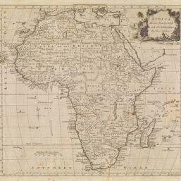
Africa Drawn the Latest and best Authorities
Permalink
https://digital.library.illinois.edu/items/3add95e0-e946-0133-1d3d-0050569601ca-b
This item is in the public domain.
Descriptive Information
| Title | Africa Drawn the Latest and best Authorities |
| Creator | Kitchin, Thomas, 1718-1784 |
| Date | 1788 |
| Dimensions | 34 x 37 cm |
| Place of Publication | London (England) |
| Cartographic Scale | 1:25,000,000 |
| Coverage-Spatial | Africa |
| Genre | Maps |
| Language | English |
| Source | Guthrie's Geographical Grammer. London, 1788. |
| Physical Location | Professor Thomas Bassett Personal Collection |
| Bibliography |
|
| Map ID | afm0003029 |
| Rights | No Copyright - United States |
| Rights Description | This item is in the public domain. |
| Collection Title | Maps of Africa to 1900 |
| Repository | Rare Book & Manuscript Library |
| Type | Cartographic material |
| Collection | Maps of Africa to 1900 |
Download Options
|
Africa Drawn the Latest and best Authorities |
Contact us
for questions and to provide feedback.