
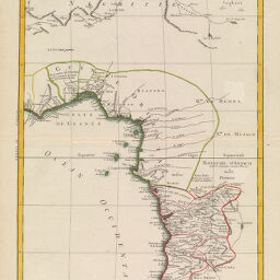
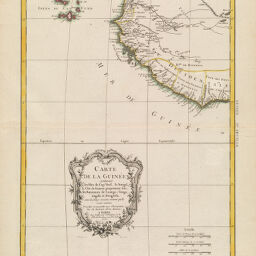
Carte de la Guinée contenant les Iles du Cap Verd, le Senegal, la Côte de Guinée proprement dite...
Permalink
https://digital.library.illinois.edu/items/3ae52600-e946-0133-1d3d-0050569601ca-e
This item is in the public domain.
Descriptive Information
| Title | Carte de la Guinée contenant les Iles du Cap Verd, le Senegal, la Côte de Guinée proprement dite... |
| Creator | Bonne, Rigobert |
| Date | 1771 |
| Dimensions | 42.5 x 31 cm |
| Place of Publication | Paris (France) |
| Cartographic Scale | 1:9,125,000 |
| Coverage-Spatial | Africa, West |
| Genre | Maps |
| Language | French |
| Physical Location | Professor Thomas Bassett Personal Collection |
| Bibliography | Guinée 1ré Feuille |
| Map ID | afm0003027 |
| Rights | No Copyright - United States |
| Rights Description | This item is in the public domain. |
| Collection Title | Maps of Africa to 1900 |
| Repository | Rare Book & Manuscript Library |
| Type | Cartographic material |
| Collection | Maps of Africa to 1900 |
Download Options
|
Carte de la Guinée contenant les Iles du Cap Verd, le Senegal, la Côte de Guinée proprement dite... | |
|
Carte de la Guinée contenant les Iles du Cap Verd, le Senegal, la Côte de Guinée proprement dite... |
Contact us
for questions and to provide feedback.