
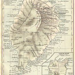
Ilha de Sao Thomé von Prof. D.R. Greeff und Francisco José de Araujo
Permalink
https://digital.library.illinois.edu/items/3b5ecaf0-e946-0133-1d3d-0050569601ca-0
This item is in the public domain.
Descriptive Information
| Title | Ilha de Sao Thomé von Prof. D.R. Greeff und Francisco José de Araujo |
| Creator | Barich, Carl |
| Date | 1884 |
| Dimensions | 24.5 x 19.5 cm |
| Place of Publication | Germany |
| Cartographic Scale | 1:250,000 |
| Notes | Relief shown by landform drawings, depths shown by soundings. Includes 1 inset map (scale 1:35,420): Ilha das Rolas. |
| Coverage-Spatial | Sao Tome and Principe |
| Subject | |
| Genre | Maps |
| Language | German |
| Color | Printed color |
| Technique | Lithography |
| Source | Petermanns geographische Mitteilungen, V. 30, plate 6. |
| Physical Location | stx |
| Map No. in Bassett and Scheven Bibliography | 2411 |
| Call Number | Q_910_5PE |
| Map ID | afm0002411 |
| Rights | No Copyright - United States |
| Rights Description | This item is in the public domain. |
| Collection Title | Maps of Africa to 1900 |
| Repository | Rare Book & Manuscript Library |
| Type | Cartographic material |
| Collection | Maps of Africa to 1900 |
Download Options
|
Ilha de Sao Thomé von Prof. D.R. Greeff und Francisco José de Araujo |
Contact us
for questions and to provide feedback.