
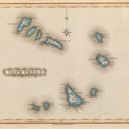
Cape Verd Ids
Permalink
https://digital.library.illinois.edu/items/3b7a13a0-e946-0133-1d3d-0050569601ca-5
This item is in the public domain.
Descriptive Information
| Title | Cape Verd Ids |
| Creator | Lucas, Fielding, Jr., 1781-1854 |
| Date | 1823 |
| Dimensions | 22.5 x 26.5 cm |
| Cartographic Scale | 1:1,625,000 |
| Coverage-Spatial | Islands--Africa |
| Genre | Maps |
| Source | General Atlas, plate 46. |
| Physical Location | rbx |
| Map No. in Bassett and Scheven Bibliography | 2409 |
| Call Number | XQ_912L962G |
| Map ID | afm0002409 |
| Rights | No Copyright - United States |
| Rights Description | This item is in the public domain. |
| Collection Title | Maps of Africa to 1900 |
| Repository | Rare Book & Manuscript Library |
| Type | Cartographic material |
| Collection | Maps of Africa to 1900 |
Download Options
|
Cape Verd Ids |
Contact us
for questions and to provide feedback.