
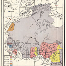
West-Coast of Africa showing European Dependencies
Permalink
https://digital.library.illinois.edu/items/3c5a0b50-e946-0133-1d3d-0050569601ca-a
This item is in the public domain.
Descriptive Information
| Title | West-Coast of Africa showing European Dependencies |
| Creator | Lucas, C. P. |
| Date | 1894 |
| Dimensions | 15 x 10 cm |
| Place of Publication | England |
| Cartographic Scale | 1:34,200,000 |
| Notes | Shows British, German, French, Spanish and Portuguese colonial territories. Relief shown by hachures. |
| Coverage-Spatial | Africa, Central |
| Subject | |
| Genre | Maps |
| Language | English |
| Color | Printed color |
| Technique | Lithography |
| Source | Historical Geography of the British Colonies, V. 3, p. 31. |
| Physical Location | stx |
| Map No. in Bassett and Scheven Bibliography | 2338 |
| Call Number | 911L96 |
| Map ID | afm0002338 |
| Rights | No Copyright - United States |
| Rights Description | This item is in the public domain. |
| Collection Title | Maps of Africa to 1900 |
| Repository | Rare Book & Manuscript Library |
| Type | Cartographic material |
| Collection | Maps of Africa to 1900 |
Download Options
|
West-Coast of Africa showing European Dependencies |
Contact us
for questions and to provide feedback.