
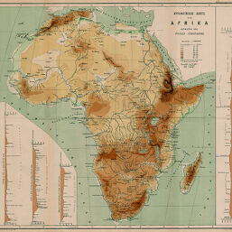
Hypsometrische Karte von Afrika
Permalink
https://digital.library.illinois.edu/items/3d0e26e0-e946-0133-1d3d-0050569601ca-5
This item is in the public domain.
Descriptive Information
| Title | Hypsometrische Karte von Afrika |
| Creator | Chavanne, Josef, 1846-1902 |
| Date | 1881 |
| Dimensions | 41.4 x 45.1 cm |
| Place of Publication | Austria |
| Cartographic Scale | 1:22,000,000 |
| Notes | Relief shown by contours and tints. Includes 4 inset elevation profiles (vertical scale 1:200,000). |
| Coverage-Spatial | Africa |
| Subject | |
| Genre | Maps |
| Language | German |
| Color | Printed color |
| Technique | Lithography |
| Source | Mitteilungen der Österreichischen Geographischen Gesellschaft, V. 24, between pp. 556-557. |
| Physical Location | stx |
| Map No. in Bassett and Scheven Bibliography | 311 |
| Call Number | 910_5GEOW |
| Map ID | afm0000311 |
| Rights | No Copyright - United States |
| Rights Description | This item is in the public domain. |
| Collection Title | Maps of Africa to 1900 |
| Repository | Rare Book & Manuscript Library |
| Type | Cartographic material |
| Collection | Maps of Africa to 1900 |
Download Options
|
Hypsometrische Karte von Afrika |
Contact us
for questions and to provide feedback.