
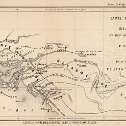
Carte de l'Archipel des Bissagos et des Contrées voisines
Permalink
https://digital.library.illinois.edu/items/3d458a30-e946-0133-1d3d-0050569601ca-0
This item is in the public domain.
Descriptive Information
| Title | Carte de l'Archipel des Bissagos et des Contrées voisines |
| Creator | Antichan, P.-H. |
| Date | 1882 |
| Dimensions | 15.5 x 29 cm |
| Place of Publication | France |
| Cartographic Scale | 1:2,850,000 |
| Coverage-Spatial | Africa, West |
| Genre | Maps |
| Language | French |
| Color | Hand colored |
| Technique | Lithography |
| Source | Revue de geographie, V. 11, between pp. 400-401. |
| Physical Location | stx |
| Map No. in Bassett and Scheven Bibliography | 2261 |
| Call Number | 910_5RE |
| Map ID | afm0002261 |
| Rights | No Copyright - United States |
| Rights Description | This item is in the public domain. |
| Collection Title | Maps of Africa to 1900 |
| Repository | Rare Book & Manuscript Library |
| Type | Cartographic material |
| Collection | Maps of Africa to 1900 |
Download Options
|
Carte de l'Archipel des Bissagos et des Contrées voisines |
Contact us
for questions and to provide feedback.