
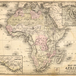
Map of Africa
Permalink
https://digital.library.illinois.edu/items/3d6d8a30-e946-0133-1d3d-0050569601ca-d
This item is in the public domain.
Descriptive Information
| Title | Map of Africa |
| Creator | Lippincott, J. B. (Joshua Ballinger), 1813-1886 |
| Date | 1886 |
| Dimensions | 22 x 27 cm |
| Place of Publication | United States |
| Cartographic Scale | 1:40,000,000 |
| Notes | Includes map of Ohio on same scale and 2 inset maps: Liberia and Sierra Leone -- Map of Northern Egypt. |
| Coverage-Spatial | Africa |
| Subject | |
| Genre | Maps |
| Language | English |
| Color | Hand colored |
| Technique | Lithography |
| Source | Popular Family Atlas, p. 22. |
| Physical Location | stx |
| Map No. in Bassett and Scheven Bibliography | 346 |
| Call Number | Q_912L66P |
| Map ID | afm0000346 |
| Rights | No Copyright - United States |
| Rights Description | This item is in the public domain. |
| Collection Title | Maps of Africa to 1900 |
| Repository | Rare Book & Manuscript Library |
| Type | Cartographic material |
| Collection | Maps of Africa to 1900 |
Download Options
|
Map of Africa |
Contact us
for questions and to provide feedback.