
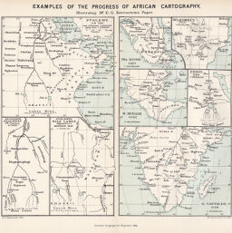
Examples of the Progress of African Cartography, illustrating Mr. E.G. Ravenstein's Paper
Permalink
https://digital.library.illinois.edu/items/3df42200-e946-0133-1d3d-0050569601ca-1
This item is in the public domain.
Descriptive Information
| Title | Examples of the Progress of African Cartography, illustrating Mr. E.G. Ravenstein's Paper |
| Creator | Ravenstein, Ernst Georg, 1834-1913 |
| Date | 1891 |
| Extent | Eight maps on 1 sheet |
| Dimensions | 19.3 x 22.4 cm |
| Place of Publication | England |
| Cartographic Scale | Scales differ |
| Notes | Ptolemy, A.D. 130 -- Ptolemy's Nile Lakes adjusted... -- Geograph. Fragment... -- Fra Mauro, 1457 -- Hylacomilus 1522 -- M. Behaim 1492 -- Edrisi, 1154 -- G. Gastaldo 1548. Relief shown pictorially. |
| Coverage-Spatial | Africa |
| Subject | |
| Genre | Maps |
| Language | English |
| Color | Printed color |
| Technique | Lithography |
| Source | Scottish geographical magazine, V. 7, between pp. 310-311. |
| Physical Location | stx |
| Map No. in Bassett and Scheven Bibliography | 396 |
| Call Number | 910_5SC |
| Map ID | afm0000396 |
| Rights | No Copyright - United States |
| Rights Description | This item is in the public domain. |
| Collection Title | Maps of Africa to 1900 |
| Repository | Rare Book & Manuscript Library |
| Type | Cartographic material |
| Collection | Maps of Africa to 1900 |
Download Options
|
Examples of the Progress of African Cartography, illustrating Mr. E.G. Ravenstein's Paper |
Contact us
for questions and to provide feedback.