


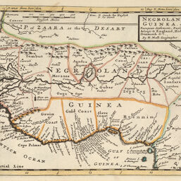
Negroland and Guinea
Permalink
https://digital.library.illinois.edu/items/3e480550-e946-0133-1d3d-0050569601ca-8
This item is in the public domain.
Descriptive Information
| Title | Negroland and Guinea |
| Creator | Moll, Herman, -1732 |
| Date | 1745 |
| Dimensions | 20.1 x 27.4 cm |
| Place of Publication | England |
| Cartographic Scale | 1:14,750,000 |
| Coverage-Spatial | Africa, West |
| Genre | Maps |
| Language | English |
| Source | Atlas minor, p. 42. |
| Physical Location | rbx |
| Map No. in Bassett and Scheven Bibliography | 2151 |
| Call Number | X912M73A1745 |
| Map ID | afm0002151 |
| Rights | No Copyright - United States |
| Rights Description | This item is in the public domain. |
| Collection Title | Maps of Africa to 1900 |
| Repository | Rare Book & Manuscript Library |
| Type | Cartographic material |
| Collection | Maps of Africa to 1900 |
Download Options
|
Negroland and Guinea |
Contact us
for questions and to provide feedback.