
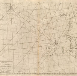
Chart of the Atlantic Ocean describing the Coast of Africa from Cape Teffalana to Cape Formosa
Permalink
https://digital.library.illinois.edu/items/3e687830-e946-0133-1d3d-0050569601ca-a
This item is in the public domain.
Descriptive Information
| Title | Chart of the Atlantic Ocean describing the Coast of Africa from Cape Teffalana to Cape Formosa |
| Creator | Knapton, John, 1696-1770 |
| Date | 1728 |
| Dimensions | 50.2 x 58.1 cm |
| Place of Publication | England |
| Cartographic Scale | 1:6,200,000 |
| Coverage-Spatial | Africa, West |
| Genre | Maps |
| Language | English |
| Source | Atlas Maritimus, plate 39. |
| Physical Location | rbx |
| Map No. in Bassett and Scheven Bibliography | 2148 |
| Call Number | XF_912AT656 |
| Map ID | afm0002148 |
| Rights | No Copyright - United States |
| Rights Description | This item is in the public domain. |
| Collection Title | Maps of Africa to 1900 |
| Repository | Rare Book & Manuscript Library |
| Type | Cartographic material |
| Collection | Maps of Africa to 1900 |
Download Options
|
Chart of the Atlantic Ocean describing the Coast of Africa from Cape Teffalana to Cape Formosa |
Contact us
for questions and to provide feedback.