
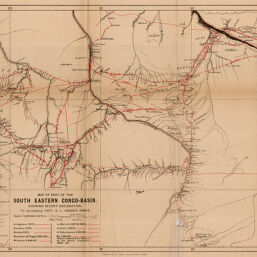
Map of Part of the South Eastern Congo-Basin.
Permalink
https://digital.library.illinois.edu/items/3ee61750-e946-0133-1d3d-0050569601ca-e
This item is in the public domain.
Descriptive Information
| Title | Map of Part of the South Eastern Congo-Basin. |
| Creator | Hinde, S. L. |
| Date | 1895 |
| Dimensions | 30.3 x 52.5 cm |
| Cartographic Scale | 1:1,000,000 |
| Notes | Relief shown by hachures. Explorers' routes indicated in red. |
| Coverage-Spatial | Congo River |
| Subject | |
| Genre | Maps |
| Language | English |
| Color | Bitonal |
| Source | The Geographical Journal, V. 5, between pp. 512-513. |
| Physical Location | stx |
| Map No. in Bassett and Scheven Bibliography | 2086 |
| Call Number | 910_5GJ |
| Map ID | afm0002086 |
| Rights | No Copyright - United States |
| Rights Description | This item is in the public domain. |
| Collection Title | Maps of Africa to 1900 |
| Repository | Rare Book & Manuscript Library |
| Type | Cartographic material |
| Collection | Maps of Africa to 1900 |
Download Options
|
Map of Part of the South Eastern Congo-Basin. |
Contact us
for questions and to provide feedback.