
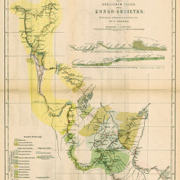
Geognostische Übersicht des Südlichen Teiles des Kongo-Gebietes
Permalink
https://digital.library.illinois.edu/items/3f16c160-e946-0133-1d3d-0050569601ca-9
This item is in the public domain.
Descriptive Information
| Title | Geognostische Übersicht des Südlichen Teiles des Kongo-Gebietes |
| Creator | Cornet, J. |
| Date | 1894 |
| Dimensions | 48.6 x 40 cm |
| Place of Publication | Germany |
| Cartographic Scale | 1:2,000,000 |
| Notes | Includes 2 geologic cross-sections. |
| Coverage-Spatial | Congo (Democratic Republic) |
| Subject | |
| Genre | Maps |
| Language | German |
| Color | Printed color |
| Technique | Lithography |
| Source | Petermanns geographische Mitteilungen, V. 40, plate 10. |
| Physical Location | stx |
| Map No. in Bassett and Scheven Bibliography | 2066 |
| Call Number | Q_910_5PE |
| Map ID | afm0002066 |
| Rights | No Copyright - United States |
| Rights Description | This item is in the public domain. |
| Collection Title | Maps of Africa to 1900 |
| Repository | Rare Book & Manuscript Library |
| Type | Cartographic material |
| Collection | Maps of Africa to 1900 |
Download Options
|
Geognostische Übersicht des Südlichen Teiles des Kongo-Gebietes |
Contact us
for questions and to provide feedback.