
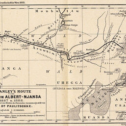
H. Stanley's Route vom Congo zum Albert-Njansa 1887 u. 1888
Permalink
https://digital.library.illinois.edu/items/3f8a3d50-e946-0133-1d3d-0050569601ca-a
This item is in the public domain.
Descriptive Information
| Title | H. Stanley's Route vom Congo zum Albert-Njansa 1887 u. 1888 |
| Creator | Paulitschke, Philipp, 1854-1899 |
| Date | 1889 |
| Dimensions | 13.8 x 21.4 cm |
| Cartographic Scale | 1:3,700,000 |
| Notes | Relief shown by hachures and spot heights. |
| Coverage-Spatial | Albert, Lake (Congo and Uganda) |
| Subject | |
| Genre | Maps |
| Language | German |
| Color | Bitonal |
| Technique | Lithography |
| Source | Mitteilungen der Österreichischen Geographischen Gesellschaft, V. 32, between pp. 240-241. |
| Physical Location | stx |
| Map No. in Bassett and Scheven Bibliography | 2013 |
| Call Number | 910_5GEOW |
| Map ID | afm0002013 |
| Rights | No Copyright - United States |
| Rights Description | This item is in the public domain. |
| Collection Title | Maps of Africa to 1900 |
| Repository | Rare Book & Manuscript Library |
| Type | Cartographic material |
| Collection | Maps of Africa to 1900 |
Download Options
|
H. Stanley's Route vom Congo zum Albert-Njansa 1887 u. 1888 |
Contact us
for questions and to provide feedback.