


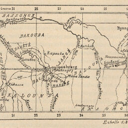
Croquis des environs de Loulouabourg
Permalink
https://digital.library.illinois.edu/items/3fca7590-e946-0133-1d3d-0050569601ca-f
This item is in the public domain.
Descriptive Information
| Title | Croquis des environs de Loulouabourg |
| Creator | Société Royale Belge de Géographie |
| Date | 1887 |
| Dimensions | 6.8 x 10 cm |
| Cartographic Scale | 1:8,000,000 |
| Coverage-Spatial | Africa, Central |
| Genre | Maps |
| Language | French |
| Color | Bitonal |
| Technique | Lithography |
| Source | Bulletin / Société belge de géographie, V. 11, No. 1, p. 102. |
| Physical Location | stx |
| Map No. in Bassett and Scheven Bibliography | 1990 |
| Call Number | 910_6SRB |
| Map ID | afm0001990 |
| Rights | No Copyright - United States |
| Rights Description | This item is in the public domain. |
| Collection Title | Maps of Africa to 1900 |
| Repository | Rare Book & Manuscript Library |
| Type | Cartographic material |
| Collection | Maps of Africa to 1900 |
Download Options
|
Croquis des environs de Loulouabourg |
Contact us
for questions and to provide feedback.