
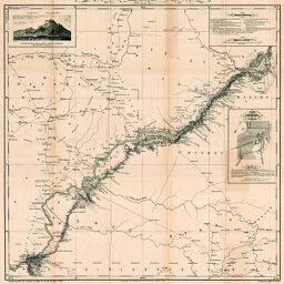
Route von Ango-Ango nach Leopoldville...
Permalink
https://digital.library.illinois.edu/items/3fff1d70-e946-0133-1d3d-0050569601ca-9
This item is in the public domain.
Descriptive Information
| Title | Route von Ango-Ango nach Leopoldville... |
| Creator | Baumann, Oskar, 1864-1899 |
| Date | 1886 |
| Dimensions | 57.4 x 57.2 cm |
| Place of Publication | Austria |
| Cartographic Scale | 1:400,000 |
| Notes | Vignette of “Ansicht des Berges Manga Bidi südlich von Lukande” and 1 inset map: Plan von Leopoldville am Stanleypool." "Mitglied der von Professor Oscar Lenz geleiten österreichischen Kong-Expedition.” |
| Coverage-Spatial | Ango (Congo) |
| Subject | |
| Genre | Maps |
| Language | German |
| Color | Bitonal |
| Technique | Lithography |
| Source | Mitteilungen der Österreichischen Geographischen Gesellschaft, V. 29, after p. 702. |
| Physical Location | stx |
| Map No. in Bassett and Scheven Bibliography | 1950 |
| Call Number | 910_5GEOW |
| Map ID | afm0001950 |
| Rights | No Copyright - United States |
| Rights Description | This item is in the public domain. |
| Collection Title | Maps of Africa to 1900 |
| Repository | Rare Book & Manuscript Library |
| Type | Cartographic material |
| Collection | Maps of Africa to 1900 |
Download Options
|
Route von Ango-Ango nach Leopoldville... |
Contact us
for questions and to provide feedback.