
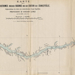
Karte des Congostromes zwischen Kasonge und der Station der Stanleyfälle
Permalink
https://digital.library.illinois.edu/items/40073f90-e946-0133-1d3d-0050569601ca-f
This item is in the public domain.
Descriptive Information
| Title | Karte des Congostromes zwischen Kasonge und der Station der Stanleyfälle |
| Creator | Lenz, Oscar |
| Date | 1886 |
| Dimensions | 52.6 x 22 cm |
| Place of Publication | Austria |
| Cartographic Scale | 1:1,140,000 |
| Coverage-Spatial | Congo River |
| Subject | |
| Genre | Maps |
| Language | German |
| Color | Printed color |
| Technique | Lithography |
| Source | Mitteilungen der Osterreichischen Geographischen Gesellschaft, V. 29, after p. 702. |
| Physical Location | stx |
| Map No. in Bassett and Scheven Bibliography | 1957 |
| Call Number | 910_5GEOW |
| Map ID | afm0001957 |
| Rights | No Copyright - United States |
| Rights Description | This item is in the public domain. |
| Collection Title | Maps of Africa to 1900 |
| Repository | Rare Book & Manuscript Library |
| Type | Cartographic material |
| Collection | Maps of Africa to 1900 |
Download Options
|
Karte des Congostromes zwischen Kasonge und der Station der Stanleyfälle |
Contact us
for questions and to provide feedback.