


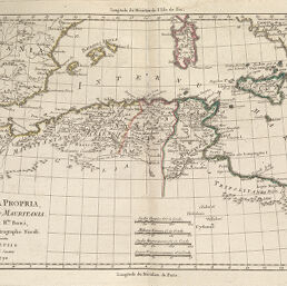
Africa Propria, Numidia et Mauritania
Permalink
https://digital.library.illinois.edu/items/4065c570-e946-0133-1d3d-0050569601ca-b
This item is in the public domain.
Descriptive Information
| Title | Africa Propria, Numidia et Mauritania |
| Creator | Grenet, abbé, 1750- |
| Date | 1790 |
| Dimensions | 20.8 x 32 cm |
| Place of Publication | Italy |
| Cartographic Scale | 1:7,000,000 |
| Coverage-Spatial | Africa, North |
| Genre | Maps |
| Language | Latin |
| Source | Compendio, plate 66. |
| Physical Location | rbx |
| Map No. in Bassett and Scheven Bibliography | 647 |
| Call Number | X912_G86C |
| Map ID | afm0000647 |
| Rights | No Copyright - United States |
| Rights Description | This item is in the public domain. |
| Collection Title | Maps of Africa to 1900 |
| Repository | Rare Book & Manuscript Library |
| Type | Cartographic material |
| Collection | Maps of Africa to 1900 |
Download Options
|
Africa Propria, Numidia et Mauritania |
Contact us
for questions and to provide feedback.