
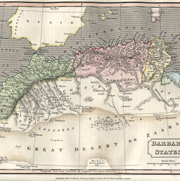
Barbary States
Permalink
https://digital.library.illinois.edu/items/409e7c50-e946-0133-1d3d-0050569601ca-d
This item is in the public domain.
Descriptive Information
| Title | Barbary States |
| Creator | Thomson, Joseph, 1858-1895 |
| Date | 1822 |
| Dimensions | 19 x 24 cm |
| Place of Publication | England |
| Cartographic Scale | 1:9,900,000 |
| Notes | Relief shown by landform drawings. |
| Coverage-Spatial | Barbary Coast |
| Subject | |
| Genre | Maps |
| Language | English |
| Color | Hand colored |
| Technique | Etched or engraved |
| Source | New and Comprehensive System, V. 2, p. 409. |
| Physical Location | stx |
| Map No. in Bassett and Scheven Bibliography | 670 |
| Call Number | Q_910M99N |
| Map ID | afm0000670 |
| Rights | No Copyright - United States |
| Rights Description | This item is in the public domain. |
| Collection Title | Maps of Africa to 1900 |
| Repository | Rare Book & Manuscript Library |
| Type | Cartographic material |
| Collection | Maps of Africa to 1900 |
Download Options
|
Barbary States |
Contact us
for questions and to provide feedback.