


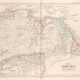
Die Nordkste Africas: gypten, Nubien, Habesch nach den besten Quellen entworsen und gezeichnet
Permalink
https://digital.library.illinois.edu/items/40da0670-e946-0133-1d3d-0050569601ca-3
This item is in the public domain.
Descriptive Information
| Title | Die Nordkste Africas: gypten, Nubien, Habesch nach den besten Quellen entworsen und gezeichnet |
| Creator | Glaser, Karl |
| Date | 1838 |
| Dimensions | 32.7 x 41.9 cm |
| Place of Publication | Germany |
| Cartographic Scale | 1:14,500,000 |
| Notes | Has inset map of Algier. |
| Coverage-Spatial | Africa, North |
| Genre | Maps |
| Language | German |
| Color | Hand colored |
| Source | Vollständiger Atlas über alle Theile der Erde [cartographic material], plate 32. |
| Physical Location | maos |
| Map No. in Bassett and Scheven Bibliography | 690 |
| Call Number | F_912G46Y1838 |
| Map ID | afm0000690 |
| Rights | No Copyright - United States |
| Rights Description | This item is in the public domain. |
| Collection Title | Maps of Africa to 1900 |
| Repository | Rare Book & Manuscript Library |
| Type | Cartographic material |
| Collection | Maps of Africa to 1900 |
Download Options
|
Die Nordkste Africas: gypten, Nubien, Habesch nach den besten Quellen entworsen und gezeichnet |
Contact us
for questions and to provide feedback.