
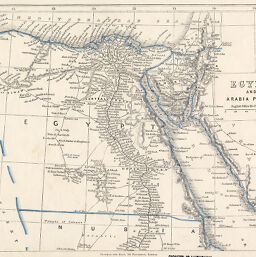
Egypt and Arabia Petrea
Permalink
https://digital.library.illinois.edu/items/40f14150-e946-0133-1d3d-0050569601ca-c
This item is in the public domain.
Descriptive Information
| Title | Egypt and Arabia Petrea |
| Creator | Chapman and Hall |
| Date | 1850-1859 |
| Dimensions | 21 x 28.5 cm |
| Place of Publication | England |
| Cartographic Scale | 1:5,450,000 |
| Notes | Relief shown by hachures. |
| Coverage-Spatial | Egypt |
| Subject | |
| Genre | Maps |
| Language | English |
| Color | Printed color |
| Technique | Lithography |
| Source | Loose sheet |
| Physical Location | mar |
| Map No. in Bassett and Scheven Bibliography | 696 |
| Call Number | G8300 1850 _C4 |
| Map ID | afm0000696 |
| Rights | No Copyright - United States |
| Rights Description | This item is in the public domain. |
| Collection Title | Maps of Africa to 1900 |
| Repository | Rare Book & Manuscript Library |
| Type | Cartographic material |
| Collection | Maps of Africa to 1900 |
Download Options
|
Egypt and Arabia Petrea |
Contact us
for questions and to provide feedback.