
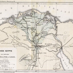
Basse Egypte avec indication des Chemins de Fer et Canaux
Permalink
https://digital.library.illinois.edu/items/41287730-e946-0133-1d3d-0050569601ca-b
This item is in the public domain.
Descriptive Information
| Title | Basse Egypte avec indication des Chemins de Fer et Canaux |
| Creator | J. Wurster and Co. |
| Date | 1860 |
| Dimensions | 13 x 16.7 cm |
| Place of Publication | Switzerland |
| Cartographic Scale | 1:2,600,000 |
| Notes | Second panel shows regions surrounding the Red Sea. Relief shown by hachures. |
| Coverage-Spatial | Nile River Delta (Egypt) |
| Subject | |
| Genre | Maps |
| Language | French |
| Color | Printed color |
| Technique | Lithography |
| Source | Le Globe : bulletin et mémoires de la Société de géographie de GeneÌve, V. 1, between pp. 114-115. |
| Physical Location | stx |
| Map No. in Bassett and Scheven Bibliography | 720 |
| Call Number | 910_5GLO |
| Map ID | afm0000720 |
| Rights | No Copyright - United States |
| Rights Description | This item is in the public domain. |
| Collection Title | Maps of Africa to 1900 |
| Repository | Rare Book & Manuscript Library |
| Type | Cartographic material |
| Collection | Maps of Africa to 1900 |
Download Options
|
Basse Egypte avec indication des Chemins de Fer et Canaux |
Contact us
for questions and to provide feedback.