
South Africa
Permalink
https://digital.library.illinois.edu/items/41459720-e946-0133-1d3d-0050569601ca-f
This item is in the public domain.
Descriptive Information
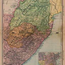
| Title | South Africa |
| Creator | Rand McNally and Company |
| Date | 1899 |
| Dimensions | 46 x 32.7 cm |
| Place of Publication | United States |
| Cartographic Scale | 1:3,070,000 |
| Notes |
|
| Coverage-Spatial | Orange Free State |
| Subject | |
| Genre | Maps |
| Language | English |
| Color | Printed color |
| Technique | Lithography |
| Source | Equitable's Atlas, p. 9. |
| Physical Location | stx |
| Map No. in Bassett and Scheven Bibliography | 1811 |
| Call Number | Q_912EQ5A |
| Map ID | afm0001811 |
| Rights | No Copyright - United States |
| Rights Description | This item is in the public domain. |
| Collection Title | Maps of Africa to 1900 |
| Repository | Rare Book & Manuscript Library |
| Type | Cartographic material |
| Collection | Maps of Africa to 1900 |
Download Options
|
South Africa |
Contact us
for questions and to provide feedback.