


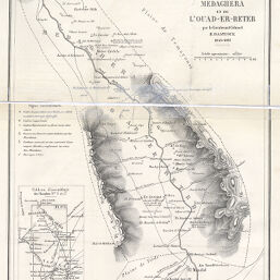
Circonscriptions de Medaghera et de l'Ouad-Er-Reteb par le Lieutenant Colonel H. Dastugue 1859-1861
Permalink
https://digital.library.illinois.edu/items/4196d370-e946-0133-1d3d-0050569601ca-7
This item is in the public domain.
Descriptive Information
| Title | Circonscriptions de Medaghera et de l'Ouad-Er-Reteb par le Lieutenant Colonel H. Dastugue 1859-1861 |
| Date | 1867 |
| Dimensions | 30.6 x 22.9 cm |
| Place of Publication | France |
| Cartographic Scale | 1:200,000 |
| Notes | Needs repair. |
| Coverage-Spatial | Africa, North |
| Genre | Maps |
| Language | French |
| Color | Bitonal |
| Technique | Lithography |
| Source | Bulletin de la Société de géographie, ser. 5, V. 13, between pp. 432-433. |
| Physical Location | stx |
| Map No. in Bassett and Scheven Bibliography | 757 |
| Call Number | 910_6SOGEASER_5 |
| Map ID | afm0000757 |
| Rights | No Copyright - United States |
| Rights Description | This item is in the public domain. |
| Collection Title | Maps of Africa to 1900 |
| Repository | Rare Book & Manuscript Library |
| Type | Cartographic material |
| Collection | Maps of Africa to 1900 |
Download Options
|
Circonscriptions de Medaghera et de l'Ouad-Er-Reteb par le Lieutenant Colonel H. Dastugue 1859-1861 |
Contact us
for questions and to provide feedback.