
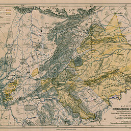
Map of the Zoutpansberg Goldfields
Permalink
https://digital.library.illinois.edu/items/419cc4c0-e946-0133-1d3d-0050569601ca-4
This item is in the public domain.
Descriptive Information
| Title | Map of the Zoutpansberg Goldfields |
| Creator | Jeppe, Frederick |
| Date | 1893 |
| Dimensions | 30.9 x 40.6 cm |
| Place of Publication | England |
| Cartographic Scale | 1:595,000 |
| Notes | Relief shown by contoured hachures. |
| Coverage-Spatial | Soutpansberg (South Africa) |
| Subject | |
| Genre | Maps |
| Language | English |
| Color | Printed color |
| Technique | Lithography |
| Source | The Geographical Journal, V. 2, between pp. 288-289. |
| Physical Location | stx |
| Map No. in Bassett and Scheven Bibliography | 1769 |
| Call Number | 910_5GJ |
| Map ID | afm0001769 |
| Rights | No Copyright - United States |
| Rights Description | This item is in the public domain. |
| Collection Title | Maps of Africa to 1900 |
| Repository | Rare Book & Manuscript Library |
| Type | Cartographic material |
| Collection | Maps of Africa to 1900 |
Download Options
|
Map of the Zoutpansberg Goldfields |
Contact us
for questions and to provide feedback.