


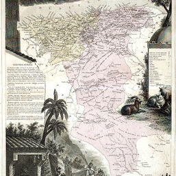
Province d'Alger
Permalink
https://digital.library.illinois.edu/items/41a4b580-e946-0133-1d3d-0050569601ca-7
This item is in the public domain.
Descriptive Information
| Title | Province d'Alger |
| Creator | Vuillemin, A. (Alexandre), 1812- |
| Date | 1867 |
| Dimensions | 42.7 x 28.2 cm |
| Place of Publication | France |
| Cartographic Scale | 1:1,750,000 |
| Notes | Map Borderlands composed of a decorative vignette with inset statistics. Relief shown by shading. |
| Coverage-Spatial | Algeria |
| Subject | |
| Genre | Maps |
| Language | French |
| Color | Hand colored |
| Technique | Etched or engraved |
| Source | Géographie universelle |
| Physical Location | stx |
| Map No. in Bassett and Scheven Bibliography | 759 |
| Call Number | Q_912G292 |
| Map ID | afm0000759 |
| Rights | No Copyright - United States |
| Rights Description | This item is in the public domain. |
| Collection Title | Maps of Africa to 1900 |
| Repository | Rare Book & Manuscript Library |
| Type | Cartographic material |
| Collection | Maps of Africa to 1900 |
Download Options
|
Province d'Alger |
Contact us
for questions and to provide feedback.