


South Africa
Permalink
https://digital.library.illinois.edu/items/42021be0-e946-0133-1d3d-0050569601ca-a
This item is in the public domain.
Descriptive Information
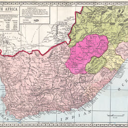
| Title | South Africa |
| Creator | Tunison, Henry Cuthbert, 1855- |
| Date | 1885 |
| Dimensions | 24 x 30 cm |
| Place of Publication | United States |
| Cartographic Scale | 1:5,420,000 |
| Notes | Relief shown by hachures. |
| Coverage-Spatial | Swaziland |
| Subject | |
| Genre | Maps |
| Language | English |
| Color | Printed color |
| Source | Peerless Universal Atlas, p. 140. |
| Physical Location | stx |
| Map No. in Bassett and Scheven Bibliography | 1719 |
| Call Number | Q_912T83P |
| Map ID | afm0001719 |
| Rights | No Copyright - United States |
| Rights Description | This item is in the public domain. |
| Collection Title | Maps of Africa to 1900 |
| Repository | Rare Book & Manuscript Library |
| Type | Cartographic material |
| Collection | Maps of Africa to 1900 |
Download Options
|
South Africa |
Contact us
for questions and to provide feedback.