


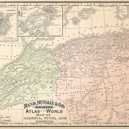
Map of Algeria, Tunis, and Morocco
Permalink
https://digital.library.illinois.edu/items/437773f0-e946-0133-1d3d-0050569601ca-1
This item is in the public domain.
Descriptive Information
| Title | Map of Algeria, Tunis, and Morocco |
| Creator | Rand McNally and Company |
| Date | 1891 |
| Dimensions | 23.5 x 32 cm |
| Place of Publication | United States |
| Cartographic Scale | 1:7,260,000 |
| Notes | Includes 2 inset maps: Algiers (1: 66,000) -- Tunis (1:340,000). |
| Coverage-Spatial | Algiers (Algeria) |
| Subject | |
| Genre | Maps |
| Language | English |
| Color | Printed color |
| Technique | Lithography |
| Source | Universal Atlas, p. 236. |
| Physical Location | stx |
| Map No. in Bassett and Scheven Bibliography | 942 |
| Call Number | Q_912R15U1894 |
| Map ID | afm0000942 |
| Rights | No Copyright - United States |
| Rights Description | This item is in the public domain. |
| Collection Title | Maps of Africa to 1900 |
| Repository | Rare Book & Manuscript Library |
| Type | Cartographic material |
| Collection | Maps of Africa to 1900 |
Download Options
|
Map of Algeria, Tunis, and Morocco |
Contact us
for questions and to provide feedback.