
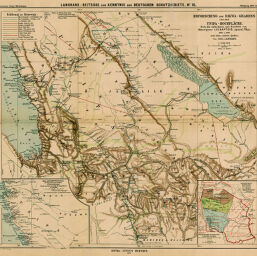
Erforschung des Rikwa-Grabens und der Ufipa-Hochflâche...
Permalink
https://digital.library.illinois.edu/items/438d0eb0-e946-0133-1d3d-0050569601ca-7
This item is in the public domain.
Descriptive Information
| Title | Erforschung des Rikwa-Grabens und der Ufipa-Hochflâche... |
| Creator | Langhans, Paul, 1867-1952 |
| Date | 1899 |
| Dimensions | 44.5 x 48.6 cm |
| Place of Publication | Germany |
| Cartographic Scale | 1:500,000 |
| Notes | Relief shown by form lines. Includes 2 inset maps: Missionsthätigkeit der Weissen Väter in Deutsch -Ostafrika -- Msgr. Lechaptois' Reise. |
| Coverage-Spatial | Tanzania |
| Subject | |
| Genre | Maps |
| Language | German |
| Color | Printed color |
| Technique | Lithography |
| Source | Petermanns geographische Mitteilungen, V. 45, plate 15. |
| Physical Location | stx |
| Map No. in Bassett and Scheven Bibliography | 1555 |
| Call Number | Q_910_5PE |
| Map ID | afm0001555 |
| Rights | No Copyright - United States |
| Rights Description | This item is in the public domain. |
| Collection Title | Maps of Africa to 1900 |
| Repository | Rare Book & Manuscript Library |
| Type | Cartographic material |
| Collection | Maps of Africa to 1900 |
Download Options
|
Erforschung des Rikwa-Grabens und der Ufipa-Hochflâche... |
Contact us
for questions and to provide feedback.