
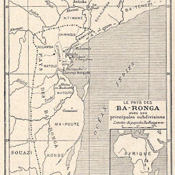
Le Pays des Ba-Ronga avec ses principales subdivisions
Permalink
https://digital.library.illinois.edu/items/43b49ca0-e946-0133-1d3d-0050569601ca-3
This item is in the public domain.
Descriptive Information
| Title | Le Pays des Ba-Ronga avec ses principales subdivisions |
| Creator | Junod, Henri Alexandre, 1863-1934 |
| Date | 1898 |
| Dimensions | 10.6 x 7.6 cm |
| Place of Publication | Switzerland |
| Cartographic Scale | 1:3,600,000 |
| Notes | Includes 1 inset map: Situation géographique du pays des Ba-Ronga. |
| Coverage-Spatial | Mozambique |
| Subject | |
| Genre | Maps |
| Language | French |
| Color | Bitonal |
| Technique | Lithography |
| Source | Bulletin de la Société Neuchâteloise de géographie, V. 10, p. 9. |
| Physical Location | stx |
| Map No. in Bassett and Scheven Bibliography | 1546 |
| Call Number | 910_6SON |
| Map ID | afm0001546 |
| Rights | No Copyright - United States |
| Rights Description | This item is in the public domain. |
| Collection Title | Maps of Africa to 1900 |
| Repository | Rare Book & Manuscript Library |
| Type | Cartographic material |
| Collection | Maps of Africa to 1900 |
Download Options
|
Le Pays des Ba-Ronga avec ses principales subdivisions |
Contact us
for questions and to provide feedback.