
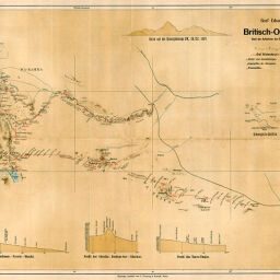
Graf Eduard Wickenburg's Reiserouten Britisch-Ost-Afrika 1897-1898. Nach den Aufnahmen des Reisenden bearbeitet von Prof. Dr. Ph. Paulitschke.
Permalink
https://digital.library.illinois.edu/items/43e5e340-e946-0133-1d3d-0050569601ca-2
This item is in the public domain.
Descriptive Information
| Title | Graf Eduard Wickenburg's Reiserouten Britisch-Ost-Afrika 1897-1898. Nach den Aufnahmen des Reisenden bearbeitet von Prof. Dr. Ph. Paulitschke. |
| Creator | Freytag, Berndt und Artaria |
| Date | 1898 |
| Dimensions | 37.9 x 62.9 cm |
| Place of Publication | Austria |
| Cartographic Scale | 1:490,000 |
| Notes | Relief shown by landform drawings and spot heights. Includes 4 elevation profiles. |
| Coverage-Spatial | East Africa Protectorate |
| Subject | |
| Genre | Maps |
| Language | German |
| Color | Printed color |
| Technique | Lithography |
| Source | Mitteilungen der Osterreichischen Geographischen Gesellschaft, V. 41, between pp. 642-643. |
| Physical Location | stx |
| Map No. in Bassett and Scheven Bibliography | 1541 |
| Call Number | 910_5GEOW |
| Map ID | afm0001541 |
| Rights | No Copyright - United States |
| Rights Description | This item is in the public domain. |
| Collection Title | Maps of Africa to 1900 |
| Repository | Rare Book & Manuscript Library |
| Type | Cartographic material |
| Collection | Maps of Africa to 1900 |
Download Options
|
Graf Eduard Wickenburg's Reiserouten Britisch-Ost-Afrika 1897-1898. Nach den Aufnahmen des Reisenden bearbeitet von Prof. Dr. Ph. Paulitschke. |
Contact us
for questions and to provide feedback.