
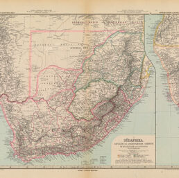
Südafrika. Capland und Angrenzende Gebiete…
Permalink
https://digital.library.illinois.edu/items/43fae160-e946-0133-1d3d-0050569601ca-8
This item is in the public domain.
Descriptive Information
| Title | Südafrika. Capland und Angrenzende Gebiete… |
| Creator | Lüddecke, Richard |
| Date | 1890 |
| Dimensions | 34 x 42 cm |
| Place of Publication | Gotha (Germany) |
| Cartographic Scale | 1:5,000,000 |
| Notes | The coast of Southwest Afrika is shown in a separate section on the right hand side of the map. |
| Coverage-Spatial | Africa, Southern |
| Genre | Maps |
| Language | German |
| Source | Stieler's Hand_Atlas. Gotha: Justus Perthes, No 70. |
| Physical Location | Professor Thomas Bassett Personal Collection |
| Map ID | afm0003093 |
| Rights | No Copyright - United States |
| Rights Description | This item is in the public domain. |
| Collection Title | Maps of Africa to 1900 |
| Repository | Rare Book & Manuscript Library |
| Type | Cartographic material |
| Collection | Maps of Africa to 1900 |
Download Options
|
Südafrika. Capland und Angrenzende Gebiete… |
Contact us
for questions and to provide feedback.