
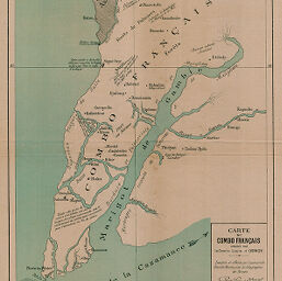
Carte du Combo Français...
Permalink
https://digital.library.illinois.edu/items/442c6260-e946-0133-1d3d-0050569601ca-5
This item is in the public domain.
Descriptive Information
| Title | Carte du Combo Français... |
| Creator | Osmoy, Louis d' |
| Date | 1893 |
| Dimensions | 39.7 x 30.9 cm |
| Place of Publication | France |
| Cartographic Scale | 1:210,000 |
| Notes | Misprint of "Congo" Français? |
| Coverage-Spatial | Atlantic Coast (Gambia) |
| Subject | |
| Genre | Maps |
| Language | French |
| Color | Printed color |
| Source | Bulletin de l'année, V. 15-16, back pocket. |
| Physical Location | stx |
| Map No. in Bassett and Scheven Bibliography | 2334 |
| Call Number | 910_6SOI |
| Map ID | afm0002334 |
| Rights | No Copyright - United States |
| Rights Description | This item is in the public domain. |
| Collection Title | Maps of Africa to 1900 |
| Repository | Rare Book & Manuscript Library |
| Type | Cartographic material |
| Collection | Maps of Africa to 1900 |
Download Options
|
Carte du Combo Français... |
Contact us
for questions and to provide feedback.