


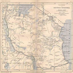
Übersichtskarte von Deutsch Ostafrika
Permalink
https://digital.library.illinois.edu/items/44a6d5a0-e946-0133-1d3d-0050569601ca-9
This item is in the public domain.
Descriptive Information
| Title | Übersichtskarte von Deutsch Ostafrika |
| Creator | Deutsche Kolonialgesellschaft |
| Date | 1896 |
| Dimensions | 25.5 x 26.5 cm |
| Place of Publication | Germany |
| Cartographic Scale | 1:5,000,000 |
| Notes | Relief shown by contours and spot heights. |
| Coverage-Spatial | German East Africa |
| Subject | |
| Genre | Maps |
| Language | German |
| Color | Printed color |
| Technique | Lithography |
| Source | Kleiner deutscher Kolonialatlas, plate 6. |
| Physical Location | stx |
| Map No. in Bassett and Scheven Bibliography | 1509 |
| Call Number | Q_912D48K |
| Map ID | afm0001509 |
| Rights | No Copyright - United States |
| Rights Description | This item is in the public domain. |
| Collection Title | Maps of Africa to 1900 |
| Repository | Rare Book & Manuscript Library |
| Type | Cartographic material |
| Collection | Maps of Africa to 1900 |
Download Options
|
Übersichtskarte von Deutsch Ostafrika |
Contact us
for questions and to provide feedback.