
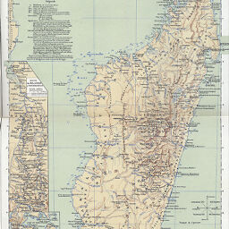
Madagascar
Permalink
https://digital.library.illinois.edu/items/44f11880-e946-0133-1d3d-0050569601ca-5
This item is in the public domain.
Descriptive Information
| Title | Madagascar |
| Creator | Mager, Henri |
| Date | 1895 |
| Dimensions | 42.3 x 28.3 cm |
| Place of Publication | France |
| Cartographic Scale | 1:4,100,000 |
| Notes | Includes insets: Route de Majunga à Tananarive -- Diego-Suarez et sa baie -- Relations entre la France et Madagascar -- Route de Tamatave à Tananarive. |
| Coverage-Spatial | Madagascar |
| Subject | Topographic |
| Genre | Maps |
| Color | Printed color |
| Technique | Lithography |
| Source | Bulletin de l'année, V. 17, between pp. 82-83. |
| Physical Location | stx |
| Map No. in Bassett and Scheven Bibliography | 1491 |
| Call Number | 910_6SOI |
| Map ID | afm0001491 |
| Rights | No Copyright - United States |
| Rights Description | This item is in the public domain. |
| Collection Title | Maps of Africa to 1900 |
| Repository | Rare Book & Manuscript Library |
| Type | Cartographic material |
| Collection | Maps of Africa to 1900 |
Download Options
|
Madagascar |
Contact us
for questions and to provide feedback.