
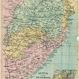
New War Map of the Transvaal and South Africa
Permalink
https://digital.library.illinois.edu/items/45327e20-e946-0133-1d3d-0050569601ca-1
This item is in the public domain.
Descriptive Information
| Title | New War Map of the Transvaal and South Africa |
| Creator | Smith, John L., 1846-1921 |
| Date | 1899 |
| Dimensions | 89 x 59 cm |
| Place of Publication |
|
| Publisher | Smith, J.L. |
| Cartographic Scale | 1:6,250,000 |
| Notes | Includes 1 inset location map. |
| Coverage-Spatial | South Africa |
| Subject | |
| Genre | Maps |
| Language | English |
| Color | Printed color |
| Source | Loose sheet |
| Physical Location | mar |
| Map No. in Bassett and Scheven Bibliography | 1815 |
| Call Number | G85001899_S5 (not G8500 1899 _J2?) |
| Map ID | afm0001815 |
| Rights | No Copyright - United States |
| Rights Description | This item is in the public domain. |
| Collection Title | Maps of Africa to 1900 |
| Repository | Rare Book & Manuscript Library |
| Type | Cartographic material |
| Collection | Maps of Africa to 1900 |
Download Options
|
New War Map of the Transvaal and South Africa |
Contact us
for questions and to provide feedback.