
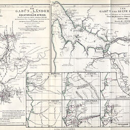
Die Gabun-Lander im ÄquatorialenAfrika...; Der Gabun und Seine Zuflüsse
Permalink
https://digital.library.illinois.edu/items/45403ba0-e946-0133-1d3d-0050569601ca-6
This item is in the public domain.
Descriptive Information
| Title | Die Gabun-Lander im ÄquatorialenAfrika...; Der Gabun und Seine Zuflüsse |
| Creator | Petermann, A. (August), 1822-1878 |
| Date | 1862 |
| Extent | 2 maps on 1 sheet and 6 inset maps |
| Dimensions | 24.5 x 42 cm |
| Cartographic Scale | 1:2,000,000 |
| Notes | Relief shown by hachures. Includes 6 inset maps indicating explorers' routes: Bowdich -- Cooley -- Kiepert -- Du Chaillu -- Barth -- Petermann. |
| Coverage-Spatial | Gabon Estuary (Gabon) |
| Subject | |
| Genre | Maps |
| Language | German |
| Color | Hand colored |
| Technique | Lithography |
| Source | Petermanns geographische Mitteilungen, V. 8, plate 8. |
| Physical Location | stx |
| Map No. in Bassett and Scheven Bibliography | 1853 |
| Call Number | Q_910_5PE |
| Map ID | afm0001853 |
| Rights | No Copyright - United States |
| Rights Description | This item is in the public domain. |
| Collection Title | Maps of Africa to 1900 |
| Repository | Rare Book & Manuscript Library |
| Type | Cartographic material |
| Collection | Maps of Africa to 1900 |
Download Options
|
Die Gabun-Lander im ÄquatorialenAfrika...; Der Gabun und Seine Zuflüsse |
Contact us
for questions and to provide feedback.