
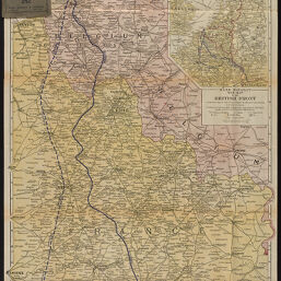
Rand McNally war map of the British front: a strategic map of the battle ground in Belgium and France, from Ostend to St. Quentin, showing the farthest advance of the Germans in 1914 and the battle line in 1917
Permalink
https://digital.library.illinois.edu/items/459ca590-b096-0136-5269-0050569601ca-2
No Copyright - United States
Descriptive Information
| Title | Rand McNally war map of the British front: a strategic map of the battle ground in Belgium and France, from Ostend to St. Quentin, showing the farthest advance of the Germans in 1914 and the battle line in 1917 |
| Creator | Rand McNally and Company |
| Scale | Scale 1:253,440. 1 in. = 4 miles |
| Coordinates | (E 2⁰17ʹ--E 4⁰14ʹ/N 51⁰24ʹ--N 49⁰36ʹ) |
| Place of Publication |
|
| Publisher | Rand McNally and Company |
| Date of Publication | 1917 |
| Extent | 1 map |
| Dimensions | 79 x 55 cm, on sheet 82 x 56 cm, folded in cover 16 x 10 cm |
| Notes |
|
| Coverage-Spatial | |
| Language | English |
| Subject | World War, 1914-1918 |
| Genre | Maps |
| Rights Description | No Copyright - United States |
| Type | Cartographic material |
| Repository | Map Library |
| Local Bib ID | 7995860 |
| Collection Title | World War I Maps |
| Collection | World War I Maps |
Download Options
|
7995860-001 | |

|
7995860-002 | |

|
7995860-003 |
Contact us
for questions and to provide feedback.